You are using an out of date browser. It may not display this or other websites correctly.
You should upgrade or use an alternative browser.
You should upgrade or use an alternative browser.
Newcastle
- Thread starter cyc10n
- Start date


Help Support Nissan Navara Forum:
This site may earn a commission from merchant affiliate
links, including eBay, Amazon, and others.
LLadnar
Member
Good night out, shared half a bottle of Jack Daniels Honey with Sparra + awake for over 24hrs and I'm feeling a bit wobbly lol…

pretty sure we have a trip in the making lol a boys weekend
Trip tomorrow half day meet at freemans waterhole at 8
Check out a local track or 2
We are also planning an overnight run from ellerston to nundle via a good track(apparently) with 20 odd river crossings
Plan to stay in nundle pub overnight end of first day.still a bit too cold for camping
Then travel home via new England highway on 2nd day
No kids on this trip but girls are welcome;Tracey and beck are coming
Will set dates when brad and I check our rosters and get a suitable weekend for all
the trip from point c to d will be east of route shown on link (going through ben halls gap np and hanging rock)
http://maps.google.com.au/maps?sadd...RzazFAPzMWaH0BBQ&oq=newcastle+&t=h&mra=ls&z=8
Last edited:
LLadnar
Member
I'm shore you can bring bub, Sparra and Garry are talking about leaving there kids at home, you can't leave a baby at home.
It seems rough roads are the only way to put her to sleep some days, drive along the bitumen and she cries. The go through some deep ruts, turn around and shes sound asleep! How many weeks away are you guys thinking? Ive got the next 4 weekends off so i hope its in amongst that somewhere. Pretty damn keen too. The pub sounds like a goer too, we still havent got new camping gear as yet.
By the looks of some of the river crossings you could get through them with ease unless the bridge is underwater! Ian, could you point out a few of these crossings for us, or tell us how deep you expect them to be?
This looks like the sort of drive we could do (and have done) towing the caravan. Some of the bridges are single-lane but they're concrete and don't have obvious weight limits that would preclude us (5T) going over them.
This looks like the sort of drive we could do (and have done) towing the caravan. Some of the bridges are single-lane but they're concrete and don't have obvious weight limits that would preclude us (5T) going over them.
ok so to clarifty a few things
i havent travelled this road
a workmate who rides told me about it
i cant comment on river crossings
maybee they are all dry
most of the track runs through private property
there are minimal side tracks untill nundle/ hanging rock area
there are other accomidation options apart from pub
so i guess kids could come along
HILLS OF GOLD MOTEL.
Phone / Fax (02) 6769 3222 $110 double (directly across from pub)
the pub caters for kids also
there rooms start at $ 80 double breakfast included/ $10 extra for each kid, ime sure bubs will be ok too
peel inn pub 0267693377
dave and brad suggested a friday start as it suits there roster and gives time to wind down sunday
its also my last weekend off for a while
so
how does friday 24th fit in with you guys
early start 6 am ?
should get us ther just afta lunch with time for exploring
check out the local area sat then head home mid arvo (down h/way 4 hrs tops)
Last edited:
tony
i believe you would be able to get your van through
this is more of a country drive
but ime sure we will find some fun somewhere
there are apparently some good tracks in the nundle/ hanging rock area
ide like to get to know the area a bit better for future camping trips
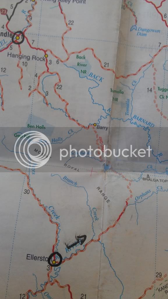
hereis a pic of map
you can see its marked 4wd only
i know camper trailers have been on the track
i believe you would be able to get your van through
this is more of a country drive
but ime sure we will find some fun somewhere
there are apparently some good tracks in the nundle/ hanging rock area
ide like to get to know the area a bit better for future camping trips
hereis a pic of map
you can see its marked 4wd only
i know camper trailers have been on the track
Last edited:
terryc
Member
Sparra How old is that map and who was it produced for and by whom?
That route marked 4WD is the route I associate with Ellerston to Nundle, but I've never been along it more than 10kms north of Ellerston and that was like 42 years ago (VBG).
We have driven what we call the Middle Route from Dungowan - Nundle -Timor - Gundy a couple of times and the northern half is sealed above Nundle and back to the highway from Nundle. We also came in the southern route (all sealed) off the highway to Nundle to get to Chaffey Dam for an overnight camp at Bowling Alley Reserve on the dam.
Going south on the middle route from Nundle was unsealed, mostly smooth(little traffic) and just a lovely drive with plenty of photostops. There was one boggy area near a soak as you crossed a saddle from the north to the south.
When we did it, it was dry and I don't remember any significant river crossings. Aka either low level rattlers or concrete or a concrete slab under water. The river crossing heights would depend on rain in the area in the week(?) prior.
Well, The Boss has indicated she is interested. Just need to find a cat sitter.
Sparra How old is that map and who was it produced for and by whom?
Well, The Boss has indicated she is interested. Just need to find a cat sitter.
terry
its an nrma map dated 2011
given to me by the guy who told me about this drive
i hope you can join us if you find someone to watch the pussy

dave ,brad are these dates suitable for you
andrew (blacnav) coming for a play ?
tony ?
i am booking a room at pub as soon as we confirm trip
I have booked the day off sparra so I'm all set to go. just got to book a room when we confirm
sweet
lets lock it in
kim coming ?
Similar threads
- Replies
- 0
- Views
- 178
- Replies
- 12
- Views
- 2K