I am planning on heading into Brindabella National Park soon to try and camp at either Lowell's Flat or McIntyres campground.
Has anyone ventured in there from Canberra who can give me some advice on navigation. I have searched around and can't find any solid maps or directions.
Cheers!
/edit
OK, did this last weekend so figured I would post a report incase anyone else wanted to give it a crack.
Here is the map (link) I would recommend if you use if you wanted to get to Lowells Flat or McIntyres Hut camping grounds. The PNG is better to print with but Imgur converts it to JPG. Let me know if you want the 7MB high res version.
We actually ended up missing the Two Sticks Road turnoff from Brindabella Road and figured instead of turning back we would give Gentle Annie Trail a go instead. I would not recommend this unless you want more 4WD action as has a lot more ups and downs and is far slower going. However, you would go this way if you wanted to camp at Flea Creek; we had lunch there and it seemed pretty good.
Eventually we made it along Webbs Ridge Trail and then onto Waterfall Trail, McIntyres Trail and finally to Lowells Flat Trail. We used the Powerline Trail and Two Sticks to get home. The turnoffs are pretty well marked so you might get away with not taking a topo map. We had the printoffs from SIX Maps from NSW, the instructions YJN gave and a hiking GPS with a similar route downloaded from another site to guide us along.
The route I have mapped was easy enough for a first time 4WDer like myself to get through without any issues. I had no idea what gears to use and whether or not to use low range at certain points. We travelled a lot slower than other 4WDs that passed us so maybe I was being a bit too careful. I'll watch a few videos on YouTube before my next outing.
Lowells Flat is a great campground. Picture perfect with plenty of room. Drop toilet that didn't stink was also a bonus. There was a sign saying there was a total fire ban but the National Parks website suggested this was not the case. Everyone else who was camping already had their fires going so we just took appropriate caution and started ours. We brought our own firewood purchased from O'Rourkes Firewood in Canberra (26c/kg!). Was bloody freezing at night and any water left out froze.
Had a bunch of palookas rock up on Saturday night, set up a fire where there was no previous fireplace, made no effort to cordon it off, played ****** music until late, rolled a huge log into their fire and then left early Sunday morning; the log was still burning on Monday morning. We poured buckets of water on it but the ground just boiled it away. Ended up having to dump sand all over it; hopefully it eventually went out.
Overall a great weekend and thanks heaps to everyone below that provided the advice I needed to get us there!

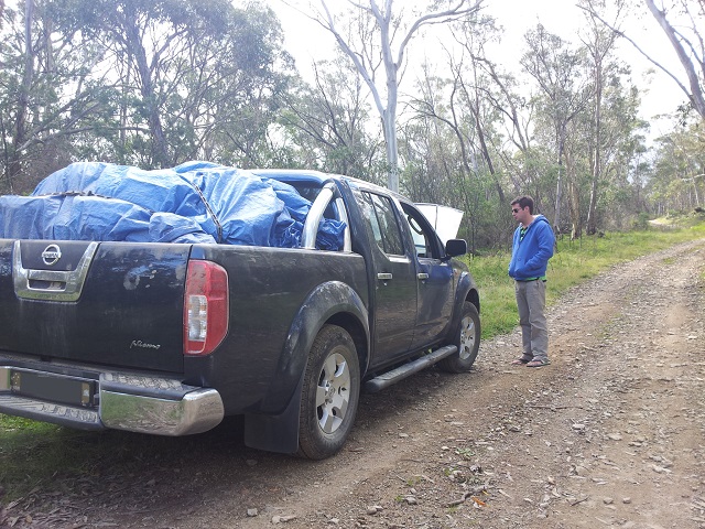
My brother making sure the engine wasn't about to explode after the smell it produced the first time we ascended in low range. Was probably just the first time it was ever really used since the previous owner said he never went off-roading.
Has anyone ventured in there from Canberra who can give me some advice on navigation. I have searched around and can't find any solid maps or directions.
Cheers!
/edit
OK, did this last weekend so figured I would post a report incase anyone else wanted to give it a crack.
Here is the map (link) I would recommend if you use if you wanted to get to Lowells Flat or McIntyres Hut camping grounds. The PNG is better to print with but Imgur converts it to JPG. Let me know if you want the 7MB high res version.
We actually ended up missing the Two Sticks Road turnoff from Brindabella Road and figured instead of turning back we would give Gentle Annie Trail a go instead. I would not recommend this unless you want more 4WD action as has a lot more ups and downs and is far slower going. However, you would go this way if you wanted to camp at Flea Creek; we had lunch there and it seemed pretty good.
Eventually we made it along Webbs Ridge Trail and then onto Waterfall Trail, McIntyres Trail and finally to Lowells Flat Trail. We used the Powerline Trail and Two Sticks to get home. The turnoffs are pretty well marked so you might get away with not taking a topo map. We had the printoffs from SIX Maps from NSW, the instructions YJN gave and a hiking GPS with a similar route downloaded from another site to guide us along.
The route I have mapped was easy enough for a first time 4WDer like myself to get through without any issues. I had no idea what gears to use and whether or not to use low range at certain points. We travelled a lot slower than other 4WDs that passed us so maybe I was being a bit too careful. I'll watch a few videos on YouTube before my next outing.
Lowells Flat is a great campground. Picture perfect with plenty of room. Drop toilet that didn't stink was also a bonus. There was a sign saying there was a total fire ban but the National Parks website suggested this was not the case. Everyone else who was camping already had their fires going so we just took appropriate caution and started ours. We brought our own firewood purchased from O'Rourkes Firewood in Canberra (26c/kg!). Was bloody freezing at night and any water left out froze.
Had a bunch of palookas rock up on Saturday night, set up a fire where there was no previous fireplace, made no effort to cordon it off, played ****** music until late, rolled a huge log into their fire and then left early Sunday morning; the log was still burning on Monday morning. We poured buckets of water on it but the ground just boiled it away. Ended up having to dump sand all over it; hopefully it eventually went out.
Overall a great weekend and thanks heaps to everyone below that provided the advice I needed to get us there!

My brother making sure the engine wasn't about to explode after the smell it produced the first time we ascended in low range. Was probably just the first time it was ever really used since the previous owner said he never went off-roading.
Last edited:


